Aberwheeler
(Aberchwiler), Denbighshire
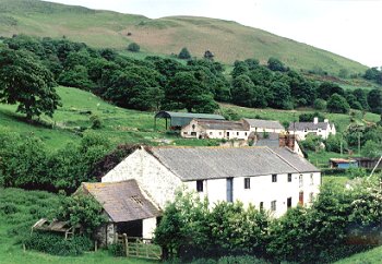
PHOTO:Ty-draw farm Aberchwiler with
Moel y Parc beyond towards the head of the Aberchwiler valley
Historic background
The earliest evidence of activity is represented by
a cremation cemetery of probable Roman date just to the north of Pontruffydd Hall, but no evidence of settlement of this period
has yet been identified in the area. The area falls within the medieval ecclesiastical parish of Bodfari and falling towards
the northern end of the commote of Dogfeilyn, in the ancient cantref of Dyffryn Clwyd.
Key historic landscape characteristics
Flat or gently sloping land along the narrow valley
of the Afon Chwiler, where it runs through the Clwydian hills, and the more open area of the vale, near Pontruffydd Hall Farm,
at the confluence of the Clwyd and Afon Chwiler, rising gently from about 25m OD on the west to about 60m OD on the east.
The Aberchwiler valley itself was described by Pennant as 'narrow, fertile, diversified with groves, and watered by the crystal
Wheeler' (Pennant 1783, 27). The eastern side of the area forms part of the Clwydian Range AONB.
Evidence of early settlement is limited to Pontruffydd
Hall, one of a number of larger late halls on the lower-lying ground in neighbouring area, formerly a 16th-century structure,
was replaced by a gothic-style rendered house in the 19th century, together with various other gothic features including a
gothic arch and an ornate entrance lodge, a brick walled garden, stable block and other outbuildings, rendered or in brick
the farm attached to the being described as a 'pretty ferme ornèe' by Pennant (1783, 31), together with elements of a model
farm. 18th- to 19th-century farmhouses and outbuildings at the neighbouring smaller farms such as Geinas Farm are predominantly
of brick, though some earlier stone buildings survive at both Geinas and Glan-Clwyd farms. Settlement in the narrow valley
to the east is largely restricted to 18th and 19th-century buildings built along the turnpike road including roadside inns,
water-mills and forge along the Afon Chwiler, and other structures associated with the Mold & Denbigh railway. The nucleated
settlement at Waen Aberchwiler appears to be of 19th-century date, enlarged by 20th-century housing, the Welsh Calvinistic
Presbyterian chapel at the focus of the hamlet having been first erected in 1822 and replaced forty years later.
Land-use characterised by medium to large-sized pasture
fields, with wetter lower-lying ground along banks of the Clwyd and Afon Chwiler drained by drainage dykes though parts of
the southern side of the area are still seasonally flooded. Fields generally defined by either post and wire fences or by
quickthorn hedges. Small stands of deciduous and conferous woodland to the south of Pontruffydd, and other scattered taller
alders, willows and poplars along the banks of the Afon Chwiler. Some land of parkland character around Pontruffydd Hall.
The landscape probably reflects late medieval drainage and enclosure of low-lying meadow land.
The valley of the Afon Chwiler cutting through the
middle the Clwydian hills, from early times formed an important line of communcation between the vale and the areas to the
east, being the route taken by the turnpike road in the 18th century and the railway in the 19th century between Denbigh and
Mold, both crossing the Clwyd by means of stone bridges near at Pontruffydd. The Mold & Denbigh Junction Railway was in
operation between 1869-1968, with a station at Bodfari and sidings for the Partington Steel & Iron Company at Bodfari
in 1924 (Baughan 1991, 76-9). Like the turnpike road the former railway still forms an important landscape feature within
the area, gradually becoming invaded by silver birch and alder.
Water power provided by the Afon Chwiler was harnessed
during the 18th and 19th centuries, if not earlier, and still represented today by the extant former stone-built clover mill
(for extracting clover seed) known as Candy Mill and the brick-built corn mill at Geinas, both fed by mill races drawn from
the stream. Water power appears to have also been used at for a forge at Forge Farm and possibly farm machinery at Pontryffydd
Hall Farm, where leats are visible. A brick chimney at Geinas farm appears to belong to an engine-house driving farm machinery.
The most remarkable industrial workings in the area
were the Lleweni Bleach Works by the Hon. Thomas Fitzmaurice in 1785 for treating linen produced on his Irish estates and
probably demolished along with Lleweni Hall between 1816-18 by the son (the future Lord Dinorben) of the Revd Edward Hughes
of Kinmel, who acquired the estate in 1810. This remarkable building is described by Thomas Pennant (1783), as follows:
The building, in which the operations are carried
on, is in form of a crecent: a beautiful arcade four hundred feet in extent, with a loggio in the center, graces the front;
each end finishes with a pavillion. The drying loft is an hundred and eighty feet long; the brown warehouse and lapping room
each ninety feet; and before it are five fountains, a prettiness very venial, as it ornaments a building of Dutch extraction.
But this is without parallel, whether the magnitude, the ingenuity of the machinery, or the size of the bleaching ground is
to be considered. The greatest part of the linnen bleached here is sent from the tenantry of his great estates in Ireland,
in payment of rent. Much also is sent by private persons from the neighboring counties for the mere purpose of whitening.
The vast extent to which Mr. Fitzmaurice carries this
business, is most sensibly felt in this neighborhood. May the utility of his life effectually awaken in our gentry a sense
of his merit, and the benefits resulting from his labors, and induce them to promote every design of his, calculated for the
public good.
The site of these extraordinary Palladian buildings,
'one of the very grandest of C18 industrial buildings' (Hubbard 1986, 80), are visible as earthworks at Coed y Plain, and
were probably approached by the causeway known as Hen Ffôs, to the east of Aberchwiler. Two contemporary illustrations of
the bleach works are known, a watercolour by Moses Griffiths of about 1790, and a line engraving by W. Watts after T. Sandby
(the architect) entitled 'Bleach Works at Llewenni, as at first intended to be built'.
Hubbard 1986
Moore, n.d.
Nash 1990
Nash
1998
Pennant 1783
Richards 1969